


HereItIs

Descriere HereItIs
Aplicatia HereItIs preia datele GSP ale autobuzelor/tramvaielor expuse printr-un Open Data API de catre regionalele de transport si afiseaza aceste date in timp real si in miscare pe o harta cat si pe un panou in care putem vedea pentru fiecare statie timpii estimativi de ajungere. Aceste date pot fi afisate cu orice frecventa vin de la regionalele de transport (momentan aceasta este 30 sec).
Aplicatia are hartile necesare rularii in toate marile orase din tara.
Orase active momentan cu date reale:
Iasi: aplicatia preia date dintr-un astfel de API la Iasi, totusi la Iasi sunt doua probleme: doar 90% dintre vehicole transmit date (celelalte fiind momentan defecte), iar a doua problema este ca datele din acel API expus de CTP Iasi nu contin numarul traseului pe care merge acel vehicol. Totusi HereItIs a implementat un algoritm de detectie a liniilor, astfel la Iasi apar pe harta cele 90% dintre vehicolele aflate pe drum si care transmis date GPS (in perioada imediat urmatoare CTP Iasi va fixa acestea si vor deveni automat vizibile pe harta), celalte vehicole putand fi puse pe harta de calatori prin functionalitati precu “Am vazut/Am plecat”.
Oradea: dupa luni de monitorizare a traficului, noi afisam estimativ toate vehicolele din Oradea cu o precizie de sub un minut.
In toate dintre aceste orase se poate folosi aplicatia daca ar fi un API deschis cu datele GPS ale mijloacelor de transport sau daca am gasi colaboratori pentru a o promova aplicatia pentru a fi folosita prin functionalitatea de share a locatiei autobuzelor din partea comunitatii de calatori: Alba, Arad, Brasov, Bucuresti, Cluj, Constanta, Craiova, Ploiesti, Sibiu, Timisoara, in curand si Bacau).
Principiul de functionare se baseaza pe atat pe date preluate de la regionalele de transport cat si pe inputul comunitatii de calatori.
Aplicatia este gratuita, momentan nu are nici reclame care sa deranjeze, singura conditie pentru a folosi aplicatia este sa fim solidari unii cu ceilalti si sa "sharuim" informatii despre locatia autobuzelor.
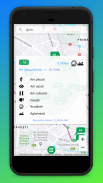
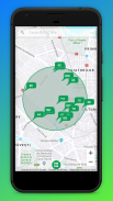
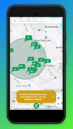
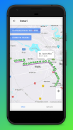
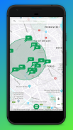
Ecranul principal al aplicatiei consta intr-o harta a orasului nostru, un cerc de 2km, o componenta de cautare si un buton cu care controlam toate actiunile pe care le putem face. De asemenea putem vedea timpii de asteptare pentru statiile apropiate de locatia mea.
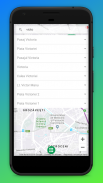
Practic incarcam pe harta doar mijloacele de transport in comun de pe o raza de un 2km fata de locatia mea curenta, desigur daca dorim sa vedem si dincolo de aceasta distanta putem folosi componenta de "Cautare", toate mijloacele de transport in comun selectate prin acea componenta devin vizibile pe harta necontand distanta fata de locatia mea. Putem defini un numar limitat momentan la 2 route "favorite", acestea vor fi vizibile pe harta pe toata suprafata orasului la incarcarea aplicatiei.
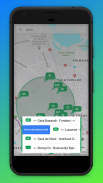
Pentru a sharui locatia unui mijloc de transport avem 2 cazuri:
1. Daca autobuzul/tramvaiul cu care intentionez sa plec nu a fost inca sharuit de altcineva ne harta, apas butonul verde -> "Am plecat", apoi din lista afisata selectez ruta dorita si directia de deplasare printr-un slide stanga sau dreapta.
2. Daca autobuzul a fost deja sharuit, dau click pe el si apas "Am plecat"
Aplicatia face validari si nu permite sharuirea de informatii decat daca userul se afla pe traseul mijlocului de transport respectiv.
Cand sharuim locatia unui mijloc de transport cu optiunea "Am plecat" aplicatia incepe sa ia recurent locatia userului curent, cu functionalitatea "Am vazut" dau voie aplicatiei sa-mi ia o singura data locatia.
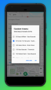
Aplicatia Necesita urmatoarele drepturi de accces:
- Conexiune la internet pentru a primit date live despre mijloacele de transport in comun
- Storage local pentru a salva cateva informatii minimale precum: numele orasului favorit si trasee favorite.
The HereItIs application takes the GSP data of the buses / trams exposed by an Open Data API by the transport regions and displays this data in real time and in motion on a map and on a panel where we can see the estimated time for each station. . This data can be displayed with any frequency coming from the regional transports (currently it is 30 sec).
The application has the necessary maps for running in all major cities in the country.
Currently active cities with real data:
Iasi: the application takes data from such an API in Iasi, however in Iasi there are two problems: only 90% of the vehicles transmit data (the others are currently defective), and the second problem is that the data from that API exposed by CTP Iasi do not contain the number of the route that vehicle goes on. However HereItIs has implemented a line detection algorithm, so in Iasi the 90% of the vehicles on the road and which have transmitted GPS data appear on the map (in the immediate period following CTP Iasi will fix these and they will become automatically visible on the map), the others vehicles that can be put on the passenger map through preconfigured “I saw / I left” functionalities.
Oradea: after months of traffic monitoring, we estimate all vehicles in Oradea with an accuracy of less than one minute.
In all of these cities the application can be used if there is an open API with the GPS data of the means of transport or if we could find collaborators to promote the application to be used through the sharing functionality of the bus location from the commuter community: Alba, Arad, Brasov, Bucharest, Cluj, Constanta, Craiova, Ploiesti, Sibiu, Timisoara, soon and Bacau).
The operating principle is based both on data taken from the transport regions and on the input of the passenger community.
The application is free, currently has no ads that bother, the only condition to use the application is to be supportive of each other and to "sharu" information about the location of buses.
The main screen of the application consists of a map of our city, a circle of 2km, a search component and a button with which we control all the actions we can do. We can also see waiting times for stations near my location.
Basically we load on the map only the means of public transport within a radius of 2km from my current location, of course if we want to see and beyond this distance we can use the "Search" component, all the means of public transport selected by that the component becomes visible on the map with no distance from my location. We can define a limited number at the moment to 2 "favorite" routes, these will be visible on the map on the entire surface of the city when loading the application.
To clear the location of a means of transport we have 2 cases:
1. If the bus / tram with which I intend to leave has not yet been shuffled by someone else on the map, press the green button -> "I left", then from the displayed list I select the desired route and the direction of travel through a left or right slide.
2. If the bus has already been shuffled, click on it and press "I left"
The application makes validations and does not allow the sharing of information unless the user is on the route of the respective means of transport.
When we share the location of a means of transport with the "I left" option, the application starts to recur the current user's location, with the "I saw" functionality, I allow the application to take my location once.
Application Requires the following access rights:
- Internet connection to receive live data on the means of public transport
- Local storage to save some minimal information such as: favorite city name and favorite routes.
HereItIs - Versiune 2020092
(21-10-2020)
HereItIs - Informații APK
Versiune APK: 2020092Pachet: com.realtime.busesCea mai recentă versiune a HereItIs


Aplicații din aceeași categorie


